


What future for the 20 km around the power plant
Immediately after the accident, the Japanese government evacuated residents from an area within a 20 km radius around the power plant and prohibited the sale of agricultural products originating from this area. The zone was subsequently expanded to include certain municipalities located outside the circle and to take into account maps showing the main radioactive deposits distributed over 40 km in the north-west direction.
The areas concerned by the evacuations covered 515 km2, including 10 inhabited, 88 cultivated and approximately 410 occupied by forests. Evacuated residents are prohibited from returning without authorization.
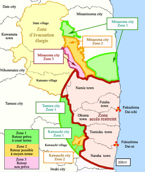
Contamination and access restrictions
The main contamination concerns a 20 km circle around the power plant and a strip extending as far as the village of Itate. The restricted-access area shown in pink corresponds to the most contaminated territories. It is surrounded by an extended evacuation zone with less stringent access restrictions. In the areas shown in green, the return of the population is planned, with the first return having been authorized in the city of Tamura in April 2014. In the orange areas, the return of the population should not be authorized in the short term. In the dark pink area of the municipality of Minamisoma, radioactive deposits are too high: the return of the population is difficult to envisage.
© IRSN (source MITI)
The evacuation decision does not necessarily mean a permanent prohibition. Before allowing evacuees to return, debris must be cleared, hot spots identified, and the area decontaminated.
Maps of ground deposits are crucial for estimating which areas may be reoccupied. The exposure doses shown on the maps are external doses derived from measurements of caesium-137 deposits, the main radioelement released, whose penetrating gamma radiation can be estimated from ground or aerial measurements. These same gamma rays are also the main contributors to external exposure.
Radioactive deposits left according to winds and rainfall are highly irregular, appearing like the spots of a leopard skin on maps. The area where the activity of caesium deposits exceeded 600 kilobecquerels per m² (kBq/m²) is approximately 600 km², compared with 13,000 km² at Chernobyl. According to IRSN, atmospheric releases of the main radioelements were between 3 and 10 times lower. During the first and most critical days, radioactive emissions generally moved away from the land, heading towards the Pacific, where most of their caesium was deposited and diluted in the depths of the vast ocean.
On 21 April 2011, the Japanese government classified the evacuation areas into three restricted-access zones, prohibiting evacuated residents from returning without authorization: • Zone where the return of the population is not envisaged, even in the long term: the external dose likely to be received is greater than 50 millisieverts per year (mSv/year). • Zones where the dose likely to be received is greater than 20 mSv/year. The return of the population is envisaged in the long term when the dose level has decreased sufficiently: only occasional returns by residents are authorized. • Zones where the lifting of the evacuation order is being prepared or is imminent: the external dose likely to be received is below 20 mSv/year. Residents will therefore be authorized to return, while observing a few basic precautions, and to resume certain industrial and agricultural activities. The first returns were authorized in early April 2014.
)
What is the risk of external exposure?
A Japanese farmer, Naoto Matsumura, following the example of the Chernobyl « samosjoly », refused the evacuation order, preferring to care for his animals even if it meant exposing himself to radiation. What future cancer risk did he expose himself to, assuming that he was exposed for 3 years to an annual dose of 50 millisieverts? Applying the standard calculation used in radiation protection, Naoto Matsumura would have a cancer risk of less than 1%.
© Source Reuters/BBC
The example of a farmer who remained in the contaminated areas shows that a person exposed for 30 years to a dose of 50 millisieverts/year would have a 92.5 out of 100 chance of not developing cancer if the « linear no-threshold relationship » between dose and effects of the International Commission on Radiological Protection, or ICRP, is applied. This calculation does not take into account local concentrations of radioactivity. In addition to external exposure, there is also the risk of direct contact with radioactive atoms in contaminated soil, inhaling dust or bringing it to the mouth. As long as the soil has not been sufficiently cleaned, residents must be evacuated or their presence limited.
Decontamination operations are being carried out in localities in order to bring the level, where feasible, below 20 millisieverts per year and allow residents to return in the longer term. Places with radioactivity levels above 50 millisieverts per year, declared uninhabitable, could remain so, but there should not be a permanent exclusion zone as extensive as that of Chernobyl.
BACK TO PAGE Fukushima: contamination