Atmospheric releases and map of ground déposits
The contaminations due to Fukushima radioactive releases are spread over a much smaller area than at Chernobyl. They are located near the damaged power plant. In addition to the fact that the releases have been ten times less important, they were shared between the mainland and the near ocean. Last important difference, the presence of liquid releases, namely highly radioactive waters on the site of the plant, a part of which went into the near sea and the rest had to be pumped, stored waiting a decontamination in progress.

Radioactive releases during the 3 first weeks
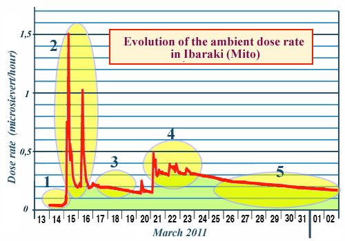
Evolution of ambient radioactivity from 13 March to 2 April in Mito, town 140 km south of Fukushima. There are several episodes: Nothing happens until the March 15 and 16 very strong peaks of radioactive pollution (2) corresponding to the massive releases of reactor 2; Then, an evolution (3) corresponding to the radiation emitted by the radioactive deposits of the two pollution peaks; a few small swings (4) signs of dispersion of new releases into the air; finally (5), a regular decrease of the radioactive deposit, sign of the absence of new pollutions arrivals.
© IRSN
Ambient dose rate surveys in the Fukushima area provided an accurate picture of radioactive releases and their magnitude during the weeks following the 11 March tsunami. The example chosen is that of the city of Ibaraki of the Mito prefecture, located 140 km south of Fukushima. This rather distant city has been relatively unexposed. The evolution of ambient radioactivity in this town shows two peaks occuring on March 15 and 16, two or three days after the partial core fusions meltings of reactors N°1, N°3 and N°2 and the large dispersions of radioactivity that followed.
The importance of the two peaks suggests that the main releae of volatile isotopes, such as iodine-131, would have occurred then, since the much smaller ambient radioactivity peaks observed after March 17 to 23 are followed by a regular decrease. This would mean that the majority of iodine and other volatile radioelements came out early of the reactors.
The bulk of the ground contamination is attributed to the explosion of the reactor N°2, which occurred on the morning of March 15th. The explosion occurred at the bottom part of the reactor. That day, the wind was blowing north-west. It was raining and snowing.
Map of early contaminations
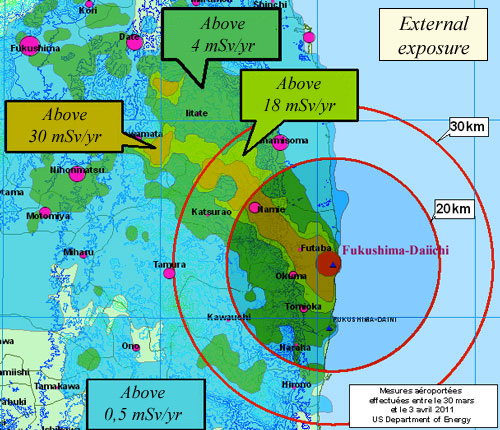
The French Institute of Radioprotection and Nuclear Safety (IRSN) drew up a map of doses of external exposure due to gamma rays emitted by ground deposits of radionuclides. The main contribution to this dose comes from cesium-137. Contamination of agricultural products, which at the time of the accident was due to deposits on leaves and grass, is replaced the following years by root uptake, a much less efficient and indirect process of uptake. As a result, from 2012, the contamination of agricultural products decreased sharply, as was observed after Chernobyl.

First map of deposits and external exposures
This map was based on measurements of ambient doses by an aircraft of the US Department of Energy (DOE) that crisscrossed the contaminated area.
© IRSN/DOE-NNSA
The resulting map provides valuable insights into the distribution of contamination. Contamination spots, distributed in a narrow band heading northwest, extend beyond the 20 km zone around the plant. Othrt areas in contrast are little affected. The surface of most contaminated area, defined by doses exceeding 30 mSv per year (the equivalent of 15 times the natural radioactivity), is small. The main contribution to this dose comes from ground deposits of cesium-137
In agglomerations, it is possible to reduce this contamination by leaching the streets and walls whenever possible. Decontamination of large areas requires careful mapping of « hot spots » where rains and runoffs may have concentrated radioactive fallout. They must be identified and decontaminated before any re-occupation of the soil. Contaminated land and objects are then stored in a specially protected dumps. (NB: The cleaning of the tsunami-devastated soil was also of great magnitude.)

Repartition of cesium-137 contamination
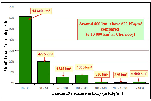
If one defines as contaminated areas, surfaces with cesium 137 deposits greater than 10 kBq / m2, the contamination resulting of the accident concern 24000 km2 in this 2012 survey (10 kBq is comparable to the natural radioactivity of a man of 80 kg). About 600 km2 exceed 600 kBq / m2 and are considered highly contaminated, compared to 13,000 km2 around Chernobyl.
© Source IRSN
The forests remains, certainly uninhabited and less sensitive to the erosion phenomenon but extremely complex to decontaminate. They represent 75% of the area affected by the accident and are expected to become the main source of radioactive pollution of the rivers in the area, since the decontamination achieved of the rice fields. In 2018, 7 years after the accident, ground contamination have been reduced owing to natural radioactive fading and decontamination actions.
Contamination has also moved due to erosion. Erosion and runoff redistribute contamination via waterways: Under their effects, ground particles containing radionuclides, including cesium, move to rivers and then gradually to the Pacific Ocean. They pass through, at the risk of contaminating them, coastal plains relatively spared by the initial fallout of the plume.
Rains, spring floods, snowmelt, typhoons, landslides have redistributed the initial cesium deposits. Typhoons, sometimes with great violence, together with snowmelt, have greatly contributed to the redistribution of ground contamination by accelerating erosion. Contaminated sediments have thus been found in initially spared areas.
But today, globally, there is a 90% decrease in radioactivity in the sediments of the rivers near Fukushima. A diminution due to three main factors: erosion during typhoons from June to October, landslides, bank landslides, and especially the decontamination actions carried out by the Japanese, especially in rice fields that are closely related to streams.
Other articles on the subject « Fukushima accident »
Fukushima : Events and Causes
March 11th 2011 : cascade of unlikely accidents … The earthquake The magnitude 9 earthquake[...]
Fukushima decontamination
2014 -2017: Status of clean-up operations The major clean-up program of contaminated areas in Jap[...]
Fukushima Health Impact
Contamination and health controls in Japan The health impacts of the accident primarily concerned[...]
Fukushima today
A long way from reactors cold shutdown to their dismantling .. Today, 8 years after the accident,[...]